The One Travel App I Can't Live Without
/
Though most people think of Google Maps as just an app for getting directions from point A to point B, there are some other features within the app that can help you plan your next trip. As a travel blogger, I often refer to Google Maps to seek out more information about hotels and attractions, plot distances, and estimate tour pacing. Here are some of my tips on how to get more out of your next Google Maps session.

Research places to go. Check for reviews from local guides. Check opening hours, read menus. Now that Google Maps has integrations like OpenTable, you can even make a reservation. No reservations available? The time graph also shows when it's the busiest time of day to visit, which can help you mentally prepare for the brunch line you're about to come across (or be pleasantly surprised when there isn't one!)

Make sure you're logged in to your Gmail account when you open Google Maps on your phone or computer. When you're logged in and looking at a place, you can star/heart/bookmark places to specific lists, which becomes really handy. I use "want to go" flags for places you wouldn't mind stopping off for to get a bite to eat or shop when I'm planning a road trip. If you're like me and you forget the names of places you visit after you leave them, simply star them to your map. In a year when your best friend says they're going to that same exact destination, you can pull up the map and look at the places you've starred to give them your best recommendations.

For trip research and inspiration, download the Google Trips app, which has the (somewhat creepy ability) to know where you've been and where you're going by searching your Gmail.
Beyond starring places, you can also create a custom map with Google My Maps. When I planned a photo walk in Minneapolis for the Libris team, I saved my starred places and potential walking routes (in different colors) to a custom map. It gave me a way to present my different ideas for stops and possible walking routes to my colleagues and helped them visualize where we'd be walking. It also gave me something to go off of once I got to town and walked the route to make sure it was just right.

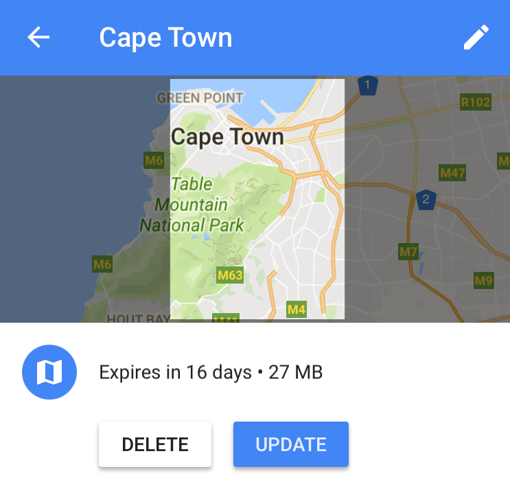
Download an offline map. This is something I blogged about in the past and was a lifesaver when I was in Paris because I was too lazy to purchase a SIM card. I didn't want to keep asking shop owners and cafes for wifi passwords, so the offline map allowed me to confidently walk all over the city without connecting to any networks.
Pay it forward! Leave reviews and add photos to help local gems be discovered by other travelers. As a Google Local Guide, you’ll be the first to know about new features and even have an opportunity to earn free Google Drive storage space.

Do you have any tips for using Google Maps? Leave a comment below.